When we told people we were going to Iceland for a week,
there were two very predictable responses.
Those who had known someone who went or visited themselves would
say: "It’s stunningly beautiful but I¢€£and
is very $$$$$, hope your wallet is
thick! " Those who had never looked into
traveling there asked “won’t you freeze?”
Although Iceland flirts with the Arctic Circle, the currents surrounding
the small country keep its weather relatively mild (but impressively windy). Our entire week was sunny with 55 degrees as
a high and about 40 as the overnight low.
I should say that we had soaring expectations for this trip.
We love the outdoors and were really looking forward to doing a good bit of
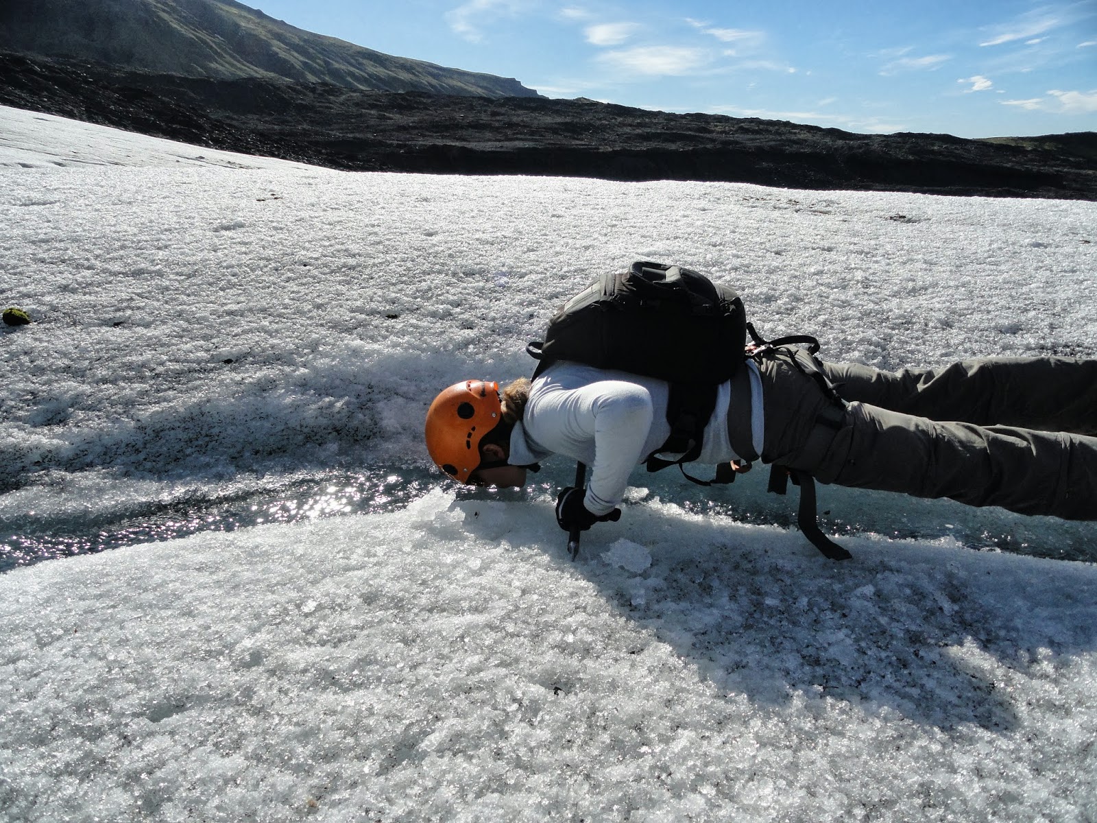
hiking, admiring waterfalls, scrambling over a glacier, climbing (inactive)
volcanoes, and picking our way over recent lava fields. Could it possibly live up to its reputation?
Iceland is roughly the size of England and most of the main
sights are along the one main ring road that circumnavigates the country. Yes, one main road. Around the entire
country. This ring road, aptly named the
‘# 1’, makes it pretty much impossible to get lost. In fact, we decided against the $12/day GPS
and, armed with only a 3’ by 2’ map of the
country, made our way in our tiny Chevy Spark out of the car rental place
and towards the #1. We had decided to
drive clockwise, passing right through the capital Reykjavik and heading
all the way north to Mývatn before continuing along the east side of the
country and back along the south coast.
I’m so, so, so thankful for Chris’s fantastic driving skills and
willingness to drive for hours at a time!
The first day was a long one, and we were amazed that in seven hours of
driving we only saw a handful of cars and maybe two trucks.
 |
| Pretty scenery, cool mountains. |
 |
| Lava field starting to get covered with lichens and early grasses. |
What we did see were horses.
Everywhere. There are 80,000 of
the small horses (pony sized, really), which we’d later find out were all one
pure breed originating from Viking times.
The rules of Iceland are really strict regarding the horses: none are
allowed to enter the country and once an Icelandic horse leaves it can’t return.
These are in place to protect the genetics and health of the breed. We asked someone why there were so many
horses, because they didn’t really look like pets or work animals. I’m
paraphrasing, but he said that some people do ride or use them on the farms but
really they’re no work to keep, so most people say ‘why not have some?’ Some people eat the meat, but you can’t make
much money selling it as an entire horse only costs around 12-15,000 ISK
(around $100-$120). The Icelandic horse
has a extra couple gaits in addition to most horses’ walk, trot, and
canter/gallop. We saw a herd of horses
being moved from one pasture to another by a few riders and stopped to take a
video. The hölt is one of the extra
gaits, which is a really smooth running walk.
I’ve never seen anything like it!
 |
| Herd of horses being driven to a new pasture. |
The scenery changed frequently as we drove around the west
section of the Ring Road. I’m not going
to lie, there was a lot of wild peeing on this trip as bathrooms were pretty
impossible to come by, except in some of the ‘towns’ we passed every hour or
two.
 |
| The tip of one of the many fjords we drove by. They're miles long, quite narrow, and a magnificent blue. |
Over and over we
heard and saw just how expensive it was to be in Iceland. Food especially is exorbitantly priced as
growing veggies requires a greenhouse and almost everything else needs to be
shipped from either North America or Europe.
To keep our costs down, we did two main things: packed a suitcase full
of food (tuna, rice, beans, bagels, peanut butter, trail mix, instant Starbucks
coffee, etc) and booked sleeping bag accommodation, a great option where farms
and campsites offer a bed without sheets.
The accommodations offered a communal kitchen, so not only did we save
huge money not staying at overpriced hotels, we also didn’t have to go out to
eat. We probably saved a thousand bucks
from those two easy modifications. That
said, we spent the last two nights at proper guesthouses, which felt
pretty luxurious!
We wanted to go to Iceland mainly because we’ve seen so many
Eden and Discovery Channel shows on its unique landscape. Humor me for a two-minute amateur geology
lesson. Basically the theory of ‘plate tectonics’, popularized only in the past
fifty or so years, finally explained why there are lines of volcanoes along the
edges of continents, why major earthquakes are clustered along (fault) lines,
and why rocks along sea floor trenches are so weirdly young. Plate tectonics theorizes the earth’s
continents and oceans are carried on huge moving plates that move in relation
to each other. The North American plate,
for example, is moving away (diverging) from the European plate at a rate of 10mm
a year, and on the other side the US, the San Andreas fault is carrying Los
Angeles north relative to the rest of California. The North American and European plates are
separated by the Mid Atlantic Rift Valley, basically around a half-mile-wide line
where the earth’s crust, only a third its normal thickness, is constantly being
remodeled from below as new earth formed by molten rock from deep within the
earth pushes apart the plates. This
particular rift runs under the ocean, except in one tiny section where it comes
up onto land…through Iceland! The rift
stretches diagonally across the country and we were able to hike around it in
the two spots it transected the ring road.
As you can imagine, these rifts
are incredibly active in a geological sense.
There are volcanoes, literal cracks in the earth from where the mounded
earth below splits the harder rock above, boiling mud pots, and spewing
geysers.
To break up the first long day of driving, we stopped to admire
the gorgeous Godafoss waterfall in northern Iceland, one of literally thousands
of waterfall in the country. It was the
first time we saw people, really, and there were only about ten of them
(tourists like us) at Godafoss. 99% of
the people we saw in Iceland were in technical clothing, which was such a
relief from the tight Euro-style flashy stuff we see everywhere else. There is no use for impractical shoes in
this country, either. I saw exactly one
pair of loafers and zero pairs of high heels in a week. My hiking boots, a fantastic present from my
in-laws a few Christmases ago, took a little beating but were perfect!
 |
| Godafoss Waterfall |
I mentioned not having a GPS, but will also mention that we
didn’t have phone or internet access for the first four days, either. Iceland has the technology, of course, but we
were feeling anti-tech and took a really nice break from constant contact.
After a day’s worth of driving along some lonely, pretty
scenery we stopped for a couple days in Mývatn in the north of Iceland. Mývatn lies in the Rift Valley and is
surrounded by the most unique landscape I’ve ever seen. We stayed right on Lake Mývatn, which was formed
when a lava flow from the nearby Krafla volcano dammed the river. The lake is a bird haven, and Chris could
name quite a few of the ducks feeding in the shallows. The earth around Mývatn literally felt alive
and it’s hard to explain just how unsettling it is to drive around a bend in
the road and see steam coming up from the ground all around. Whoa, that can’t be normal!
 |
| Lake Myvatn. |
 |
| Is the ground on fire? |
One of the coolest things we saw was Hverir, an area of boiling
mud pots and steaming fumaroles. The
ground at Hverir hissed and gurgled and the rust-colored mountain in the
background let off some crazy fumes.
There’s not a good way to capture the smell that came from some of these mud pots, but it was not for the
faint hearted. Sulfur was the
predominant barrage, but there were others in there, too. Even the water at the farmhouse was safe to
drink, but hard to get down! It tasted and smelled so strongly of boiled eggs and minerals; it's the only place I’ve ever smelled worse
upon finishing a shower. We resorted to
buying bottled water, something I hate doing, but the risk of dehydration was
real!
 |
| Fumarole, or steaming vent, in Hverir. Pictures don't capture how loud and smelly this place was! |
 |
| I looove this face! |
 |
| "Only walk on dark colored soil" White sulfur deposits indicate HOT earth. |
 |
| Close up of one of the fumaroles. |
 |
| Boiling mud pots in Hverir. The gloop, gloop, gloop sounds were so loud... it's disconcerting to watch the earth boil. |
 |
| I love Iceland's version of safety bariers. |
Iceland is full of hot springs from its underlying
geological activity. We visited one pool
that had been used for decades until the most recent eruption of the volcano
nearby heated it to unusable levels. The
Blue Lagoon near the capital city is the most famous of these hot springs,
although its downfall is increased commercialism and expense. We instead visited the Mývatn Nature Baths,
the north’s answer to the Blue Lagoon.
Of anything we did, though, this was the biggest disappointment. The water was right at body temperature but
because the wind had such a chill we couldn’t get warm enough! We stayed for
about 45 minutes before admitting we’d rather be cozy warm in our little room
in the farm house a few minutes away.
 |
| Myvatn Nature Bath. |
 |
| Myvatn Nature Bath. |
One of my absolute favorite sights in Iceland was the Krafla
volcanic area in the Rift Valley just north of Mývatn . There’s no cone shaped Krafla volcano, but rather
a series of fissures overlying a giant magma chamber. Krafla erupted as recently as 1984 and is
overdue for another. The area was so
active in the 1700’s that its lava fountains could be seen all the way across
the country, and lava flows from that time created the lake where we
stayed. The Krafla area includes the
Viti crater, one of Krafla’s many vents and a visible example of just how much energy
is coming from the earth around here. Actually,
Iceland harnesses most of its energy from geothermal sources. We drove through the Krafla Power Station,
one of many in the country, on our way to see Krafla.
 |
| Driving through the geothermal plant. |
We hiked from the parking lot to the strange Leirhnjukur mud
pot whose prettiness belies the fact that it’s the most likely place of the
area’s next eruption!
 |
| The water may look inviting, but I'd suggest not swimming in it :) |
From there we crunched through some of the newest lava flows
(from the 1984 eruption), which look and feel as though they’ve just
cooled. There was a ‘walking path’
through the whole Krafla area, which we were warned to stay on to avoid any injury. Apparently the earth’s crust is extremely thin
there and there are areas of the earth that are close to boiling! The
problem was the ‘path’ was labeled by a rare wooden stick and oftentimes the
steam (coming literally from the ground itself) was so thick it made the markers
difficult to see. It was so awesome,
although Chris’ cavalier attitude towards said marker signs caused me more than
a little panic and one “I need you alive to be this baby’s father!”
lecture. Every family needs a safety
officer…
 |
| Basically walking on top of a flat volcano... Krafla volcanic area. |
 |
| Wait, is THIS the path?? |
 |
| Lava flow from the 1984 eruption. |
We also hiked a few miles away at to the crater of the Hverfell
volcano. In typical Iceland terms, the
guidebook said this “easy walk” to the rim would take a few minutes and offer great views. At least it was was correct about the views! We were in the middle
of the rift valley and could see the roughly linear cracks in the earth around
us stretching out in either direction.
Isn’t geology fun? Oh, and I
should mention that other than the Nature Baths every single sight I’m talking
about was free to enter, free to climb around, and if there was a toilet, it
was free to use. (American Claire
scratches head in confusion.)
 |
| Hverfell crater, one of the 'vents' along the ridge. |
 |
| At the top of the crater, after our 'easy' walk to the top. It doesn't help that I'm carrying a baby, of course! |
 |
| Super impressive - geology in action... Chris standing on one of the cracks in the earth separating the European from the North American continental plates. |
On the western shore of Lake Mývatn is a group of ‘pseudocraters’ which were
formed when molten lava flowed into the lake.
Trapped subsurface water boiled and popped through the cooling
lava. That’s lifted right from a book,
though, and I’m not sure I understand the process. All I
know is they looked like mini volcanoes!
 |
| Pseudocrater. |
More to come in Part 2...